
Client Name
Lorem ipsum dolor sit amet, consectetur adipiscing elit. Ut elit tellus, luctus nec ullamcorper mattis, pulvinar dapibus leo.
Project Type
Lorem ipsum dolor sit amet, consectetur adipiscing elit. Ut elit tellus, luctus nec ullamcorper mattis, pulvinar dapibus leo.
Services Provided
Lorem ipsum dolor sit amet, consectetur adipiscing elit. Ut elit tellus, luctus nec ullamcorper mattis, pulvinar dapibus leo.
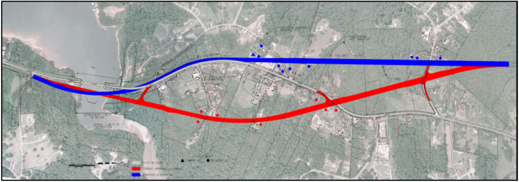
The proposed Cleveland Highway widening, reconstruction and bridge replacement project (GDOT PI Nos. 122060, 122064, 122066) is located in Hall County, GA. The project utilizes several typical sections, including a four-lane roadway with a depressed median and a four-lane roadway with a raised median. The project also widens the existing two-lane sections and proposes a one-mile new location off alignment to avoid several historical resources.
Keck + Wood began work on this project in 2006 with the concept as a single project; however, the Georgia Department of Transportation (GDOT) re-scoped the project in 2011, separating it into three separate PI numbers. The first project (PI No. 122066) was completed to address existing load-rated bridges that were in deterioration and in quick need of replacement. This required extensive coordination with the U.S. Army Corps of Engineers (USACE) for permitting the bridges across Lake Lanier. The project activities began with concept studies and ended with construction plans to replace the two deep water bridges followed by an environmental document for the roadway widening. Keck + Wood provided several services, including a Preliminary Engineering Study (PES), roadway design, utility coordination, construction support, USACE coordination, Bridge Foundation Investigation (BFI), Wall Foundation Investigation (WFI), soil survey, environmental permitting, surveying and structural design.
This was Phase I of three phases to reconstruct and widen Cleveland Highway/State Route 11, which is 2.6 miles long. Ultimately, the roadway will be realigned along a new alignment section for one mile. The new alignment section was added to bypass an area with multiple substandard curves and reduce impacts to several residences and historical properties. The project will construct an adjacent bridge to the recently constructed bridge over the East Fork Little River (Lake Lanier). The project also utilizes several typical sections, including a raised 20-foot median and a 32-foot grass median. There are three MSE walls and two standard walls throughout the project. Finally, the project is also located in an MS4 area, the Post-Construction Stormwater Report (PCSR) was completed and includes a sand filter, with other areas being infeasible.